That’s OS for Ordnance Survey, to you. It’s another map app for Android (and possibly iPhone, who knows). It is a game-changer for off-the-beaten-track navigation.
Any of you who have used paper OS maps in the past will remember the incredible level of detail and information present on the 1:25,000 scale map. Every footpath, contour line, field boundary, and stream is lovingly rendered according to the classic Ordnance Survey legend. The main issue with using these maps is twofold – they are enormous, and unless you’re keeping a close eye it’s very easy to become disorientated and think you are somewhere other than where you are.
OS Mapfinder has changed that forever. The app comes free with a 1:250,000 scale map of the entire UK which runs to about 400mb. This isn’t all that useful, but it’s free so I can’t complain. The genius is in the map tiles – you can buy any 10x10km tile in either 1:50,000 or 1:25,000 scale for £0.99 or £1.99 respectively. These are then downloaded to your device and may be used offline. The detail is marvelous and is an exact replica of the paper maps with no loss in quality. The app tells me you can use it to plan or record routes, but that functionality exists in many places. The game-changer is the fact you can instantly locate yourself on a highly portable OS map with GPS.
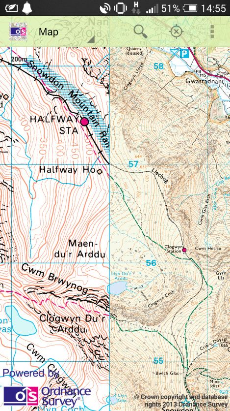
 An example of the 1:50,000 (left) and 1:25,000 (right) map details.
Bang. No more time spent arguing over whether the treeline yonder looks like this or that wooded area on the map, no more confusion over whether you’re on the right path, and no wandering out into empty void á la Google Maps. You always have the map with you, and if you need more detail for an area you haven’t purchased yet you can get it with only a smidgen of signal. I’ve used it walking in Wales and on various long walks in the south of England and it has never put a foot wrong. As a consequence, neither have I. The map is incredibly easy to use, practical, and cheaper than getting a library of paper maps which are invariably left at home.
There are only two drawbacks to OS Mapfinder vs paper versions of the same. The first is battery life – paper never runs out of power but your phone can, does, and will if you push it hard enough. I’ve had to take extra power with me on some of our longer (>8-10 hours) walks to ensure that we’ll still have navigation by the end. Secondly (and I don’t know if this is limited to HD screens) the GPS icon signifying your location is TINY to the point of being almost invisible. Multiple times I have had to move the map off centre just so when it automatically re-aligns with GPS I have some idea of where the icon is supposed to be.
Overall, though, this is the single largest change to countryside navigation I have experienced. Looking at the reviews on Google Play several people have had problems with crashes etc, but if you can get it to work it is a transformative experience.